*** Paul Piorek is editor and publisher of Paul's Local Weather Journal for southwestern Connecticut ... Paul is the on-air meteorologist at WICC 600 AM and 107.3 FM ... Paul is a New York Emmy award winner (2007), five-time Emmy nominee, and four-time winner of the Connecticut Associated Press Broadcasters' Association award for Best TV Weathercast (2006, 2008, 2009, 2012) ... Paul was voted Best Local Television Personality by the readers of Fairfield County Weekly Magazine (2012) ... Paul was inducted into the Housatonic Community College Hall of Fame and received the Distinguished Alumni Award (2012) ... The local weather journal is a two-time winner of the Communicator Award of Distinction (2012 & 2013) ... Paul is currently a full-time teacher of Earth Science and Mathematics in Fairfield ... Follow Paul on Twitter @PaulPiorekWICC ...

Tuesday, December 26, 2023

Post-Christmas Blizzard 13 Years Ago Christened Unforgettable Winter of 2010-11

A powerful blizzard, which delivered about a foot-and-a-half of snow, 60 mile-per-hour wind gusts, and power outages throughout southwestern Connecticut, struck the region 13 years ago today, triggering an unforgettable stretch of snowstorms which brought 60 inches of snow during the Winter of 2010-2011. The timing of the blizzard, which affected thousands of holiday travelers, and the magnitude of the storm made it one for the ages.


I worked the early-morning shift at News 12 Connecticut since June of 1995, and there were only a handful of truly memorable storms. However, this was the first time I wasn't able to drive to work on my own. One of my neighbors agreed to drive me to the studio in his snowplow during the height of the blizzard early Monday morning. I'm glad he did. To be sure, my Chevy Cavalier wouldn't have made the journey from Fairfield to Norwalk.

Officially, 12 inches of snow fell at Sikorsky Memorial Airport in Stratford from Sunday morning through early Monday morning. The eight inches of snow which fell December 26 marked the third snowiest December day on record in southwestern Connecticut. Only December 19, 1948 (16 inches), and December 30, 2000 (10 inches), brought more snow in one day. Here are some impressive snow totals from the 2010 post-Christmas storm: 

  • Wilton: 18"
  • New Canaan: 17.5"
  • Greenwich: 17"
  • Stratford: 16"
  • Norwalk: 16"
  • Westport: 14.8"
  • Darien: 14.5"
  • Milford: 14"
  • Bridgeport: 12"
Storm2

The biting wind was brutal if you were outside for any length of time. Sustained winds of 25 to 35 miles an hour were recorded late Sunday night and Monday, December 27, and wind gusts reached 60 miles at Sikorsky Memorial Airport in Stratford (9:21 p.m.) and Greenwich (10:00 p.m.) late Sunday evening. I was surprised that there weren't more widespread power outages.

Storm1

There's no question the blizzard of December 26, 2010, will not soon be forgotten.

Paul

Thursday, December 21, 2023

Winter Officially Begins Today in the Northern Hemisphere

Winter officially arrives in the Northern Hemisphere today at 10:27 p.m. EST. My fifth-grade students often ask me why the start of a new season doesn't begin at midnight on a certain date, much like the beginning of a new year. The answer has to do with the Earth, the tilt on its axis, and its revolution around the Sun.

I've always maintained that the start of a new season is more of an "event" than watching the ball drop in Times Square on New Year's Eve. That's because New Year's Day is a "man-made" holiday which can arbitrarily occur at any time during a calendar year. An equinox or a solstice, however, marks a precise time when the Sun's rays strike a particular point on the face of the Earth. I try to observe the arrival of a new season, and today will be no exception.


As the Earth travels around the Sun in its orbit, the North-South position of the Sun changes over the course of the year due to the changing orientation of the Earth's tilt with respect to the Sun. The dates of maximum tilt of the Earth's equator correspond to the Summer Solstice and Winter Solstice, and the dates of zero tilt correspond to the Vernal Equinox and Autumnal Equinox.

In the Northern Hemisphere, the Winter Solstice is day of the year when the Sun is farthest South. However, in the Southern Hemisphere, the Winter and Summer Solstices are the opposite, so that the Winter Solstice occurs on the first day of Summer in the Northern Hemisphere. The Sun's direct rays will be over the Tropic of Capricorn next Thursday morning.

The Winter Solstice also marks the "shortest day" of the year in terms of daylight. The length of time elapsed between Sunrise and Sunset at the Winter Solstice is at a minimum for the year. Of course, Daylight Saving Time means that the last Sunday in March has 23 hours and the first Sunday in November has 25 hours, but it does not correspond to the actual number of daylight hours.

Finally, the shadows cast by the Sun will be at their longest by the end of this week, since the Sun is at its lowest point in the sky. The actual times of Sunrise and Sunset in southwestern Connecticut for the Solstice are 7:16 a.m. and 4:27 p.m., respectively. Consider that on the first day of Summer in late June, the Sun rises at 5:19 a.m. and sets at 8:30 p.m. So, today's "length of day" is only nine hours and 11 minutes as opposed to 15 hours and 11 minutes exactly a half-year later.

So, as we prepare to welcome Winter, also realize that its arrival marks a turning point. The days will gradually begin to get longer from this point forward until the end of June. Things can only get brighter from here on out.

Paul

Wednesday, December 20, 2023

First Snowstorm of 2009-2010 Winter Season Arrived 14 Years Ago Today

The first major snowstorm of 2009-2010 blasted southwestern Connecticut 14 years ago today, with some local communities receiving close to a foot of snow. Fortunately, the storm arrived late Saturday evening, December 19, 2009, giving most people ample time to prepare well in advance. The highest snow totals were recorded across southeastern Connecticut, while parts of Litchfield County saw nothing more than a trace of snow.

Here is a look at snowfall totals from across the region from December 19 and 20, 2009:
  • Darien: 10.5"
  • New Canaan: 10.3"
  • Milford: 10"
  • Bridgeport: 9"
  • Fairfield: 9"
  • Norwalk: 8"
  • Woodbridge: 7.5"

Officially, at Sikorsky Memorial Airport in Stratford, six inches of snow fell late Saturday, December 19, and 3.2 inches accumulated Sunday, December 20, 2009, for a total of 9.2 inches. The snow happened one day before the Winter Solstice. Over a foot of snow (13.4") was recorded at the airport in December 2009, including two inches on December 9, and just over two inches on New Year's Eve day.


The normal average snowfall for December is 3.6 inches, based on 40 years of averages, or climatology. The snowiest December day on record in southwestern Connecticut happened December 19, 1948, when 16 inches blanketed the region. You may recall that 12 years ago, a foot of snow fell from December 26 through December 27, triggering one of the snowiest periods in recent memory. You may also recall the Winter storm of December 30, 2000, when ten inches fell.

Paul

Tuesday, December 19, 2023

Snowiest December Day on Record at Bridgeport Happened on This Date in 1948

The snowiest December day on record at Bridgeport happened 75 years ago today. Sixteen inches of snow fell on Sunday, December 19, 1948. It is one of only two days in December with double-digit snowfall. The other was December 30, 2000, when 10 inches fell.

Take a look at the front page of the Naugatuck Daily News from the following morning, Monday, December 20, 1948. Please click the image to enlarge and read the story.


Paul

Wednesday, December 13, 2023

Dreaming of a White Christmas

The Winter Solstice is just about one week away, and Christmas is just 12 days from now. Not surprisingly, many people have asked me about the odds of seeing a "White Christmas." Light snow is expected by mid-morning through mid-afternoon tomorrow, and one-to-two inches are possible by tomorrow evening. Another storm is possible by Saturday.

So, what are the chances of snow by Christmas? Here in southwestern Connecticut, weather records have been kept for a long time. Our climatology is based on record-keeping over a 40-year period. Based on history, shoreline communities such as Stamford, Darien, Stratford, and Milford have a 30% chance of seeing at least one inch of snow on the ground by December 25. There's a 10% chance of at least five inches of snow on the ground by then. However, we have a zero percent probability of having ten inches of snow or more on our front lawns by Christmas morning.


Inland, the odds are more favorable. People living north of the Merritt or Wilbur Cross parkways have a 57% chance of at least one inch of snow for Christmas. The odds are slightly lower than one-in-four (23%) for five inches of snow, and quite slim (3%) for at least ten inches of snow. However, residents in Wilton, Redding, Easton, and Woodbridge have a much better opportunity of seeing snow on the ground than their shoreline counterparts.

As far as the rest of New England is concerned, the chance of a white Christmas gets even better. Northern Connecticut and southern Massachusetts have about a 40 to 60% chance of at least one inch of snow; central New England's chances improve to 60 to 80 percent; and northern New England (80 to 100%) is virtually assured of having a White Christmas.

One of the more memorable snowstorms which occurred in late December was the Christmas Eve storm of 1966. We received over a half-foot of snow (6.9"), making roads quite slippery and travel very difficult. I distinctly remember my family on our way to visit my grandmother in the snow, but my parents deciding the drive wasn't worth the risk. We turned around and headed for home, but the car slid several times on the snowy roadways.

You may recall the snowstorm which delivered more than nine inches of snow to southwestern Connecticut the weekend of December 19 and 20, 2009. The snow began late Saturday evening, and six inches had accumulated by midnight. The snow tapered off early Sunday morning, but not before another 3.2 inches caused headaches for holiday shoppers the last weekend before Christmas.

Another recent snow occurred on Christmas Day, 2002. Some light snow happened early that morning, but a steadier and heavier snow developed by later in the afternoon and evening. The snow totals were quite impressive locally. Darien received 10 inches of snow by the time the storm exited the following day. Redding (9.5"), New Canaan (9.2"), Norwalk (7.0"), Greenwich (7.0"), and Westport (6.5") each saw at least a half-foot of snow!

On the flip side, I'm sure you recall December of  2006. The afternoon high temperatures from December 23 to 26 reached 58, 52, 44, and 50 degrees respectively, well above the 38-degree normal high. Over an inch of rain fell December 23 (1.15") and over a quarter-inch (0.28") was recorded on Christmas Day. We were left dreaming of snow for quite some time.

Paul

Saturday, December 2, 2023

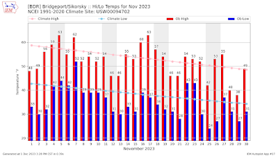
November Featured Cooler- and Slightly Drier-Than-Normal Weather Across Southwestern Connecticut

November is officially in the rear-view mirror, and the month, not surprisingly, was cooler- and drier-than-normal across southwestern Connecticut.

The average monthly temperature for the 30-day period was 43.6 degrees F, which is 2.4 degrees below normal. Twenty of the 30 days last month featured cooler-than-normal average temperatures. In fact, nine of the last 12 days of the month were colder-than-normal.

The high temperature for November at the Bridgeport climate station was 63 degrees, which occurred November 5th and 17th. The coldest temperature was 24 degrees on November 25th. Fourteen days featured a morning low of 32 degrees or colder.

More than three inches of precipitation (3.07") fell at Bridgeport, which was just 0.04" below normal for the month. Seven days featured at least one-hundredth of an inch of rain; there were four days with at least one-tenth of an inch of rain; there was one day with at least one-half inch of rain; and there was one day with at least one inch of rain.


The greatest 24-hour rainfall happened November 21st and 22nd when 2.61" fell. The first half of the month featured only one day (November 7) with more than one-hundredth of an inch of rain (0.20"). 

Paul

Thursday, November 23, 2023

Recalling the Thanksgiving Day Snowstorm 34 Years Ago

Thirty-four years later, the Thanksgiving Day snowstorm of November 23, 1989, still remains the snowiest November day on record in southwestern Connecticut. The storm, which began Wednesday evening, November 22, delivered over a half-foot of snow in less than 24 hours, while creating havoc on area roadways and major airports in the Northeast. Officially, 6.6 inches of snow fell at Sikorsky Memorial Airport in Stratford.


The first Thanksgiving Day snowstorm in 51 years postponed traditional high school football rivalry games and even prevented Snoopy and Bugs Bunny from making it to the big parade in Manhattan. Snow fell from Virginia to New England, breaking records in Boston, New Jersey, and New York City. By the time it dwindled to a flurry late Thursday, November 23, the storm delivered 4.7 inches of snow to Central Park.

Snow

The unforgettable storm was the seventh measurable Thanksgiving Day snow recorded in New York City since the National Weather Service started keeping records more than 120 years earlier. The last white Thanksgiving in the city was in 1938, when 3.9 inches of snow fell. In Newark, nearly six inches of snow fell in less than 24 hours, breaking the Thanksgiving record of four inches set in 1938.


The New York City police department said there were about 1.8 million spectators and marchers at the Macy's Thanksgiving Day Parade. They described it as a light to medium turnout. Strong gusts in the early morning tore at the seams and patches of the giant Snoopy and Bugs Bunny helium balloons, puncturing Snoopy's nose and tearing a hole in his comrade's side, a Macy's parade official, said.

Boston experienced the heaviest Thanksgiving Day snow in 65 years, and in southern New England, three to eight inches were recorded. Long Island was the hardest hit, in particular Northport and Centerport, where five to seven inches fell. In Brooklyn and New Jersey, up to five inches were reported. There were no record lows in temperature, however.

What do I most remember about the snowstorm? I just began working as the evening weather anchor at News 12 Connecticut two months earlier, and the snow caught just about everybody by surprise. Although there was some snow in the forecast, I distinctly remember telling the viewers that it shouldn't amount to much, and travel shouldn't be adversely affected. Boy, was I ever wrong!

Paul

Monday, November 6, 2023

Classic Nor'easter Dumped More Than a Half-Foot of Snow on Region 11 Years Ago Today

Just nine days after Hurricane Sandy devastated parts of southwestern Connecticut, especially shoreline communities, a classic Nor'easter brought gusty winds, cold temperatures, and record-breaking snow to the region, Wednesday, November 7, 2012. The snow began falling late-morning as the storm exploded, causing bands of moderate-to-heavy snow to fall the rest of the day and through the night.


Officially, Sikorsky Memorial Airport recorded 8.3 inches of snow from November 7 through early November 8. The six inches that fell November 7 was a record for the date and the second snowiest November day on record. More than a half-foot of snow (6.2 inches) fell on Thanksgiving Day, Thursday, November 23, 1989. Three inches of snow fell on November 27, 2002. 


Here are some of the snow totals from across southwestern Connecticut:
  • Monroe: 11.5"
  • Danbury: 9.9"
  • Bridgeport: 8.0"
  • Ridgefield: 8.0"
  • Darien: 7.9"
  • Greenwich: 6.0"
  • Trumbull: 6.0"
  • New Canaan: 6.0"
  • Norwalk: 5.8"
  • Stamford: 5.3"

A strong North wind continued to pull colder air into much of New England throughout the day. The high temperature of 39 degrees November 7 happened at 10:21 a.m. By mid-afternoon, the mercury had dropped into the low-to-mid 30s, causing the precipitation to fall as heavy wet snow. The low temperature fell to 31 degrees at 8:24 p.m. The normal high and low temperatures for November 7 are 56 and 40 degrees, respectively. The average temperature of 35 degrees on November 7 was 13 degrees colder than the normal average of 48.

Initially, it appeared the storm would be more of a wind-maker rather than a snow-maker, as computer models pushed the center of the storm farther to the East. However, the winds never reached the 50-mph forecast gusts which were anticipated. The highest wind gust at Sikorsky Airport was 36 miles per hour out of the North, and the highest wind speed was 29 miles an hour. The average wind speed during the storm was 19.2 miles an hour.

Paul

Wednesday, November 1, 2023

October Warmer And Drier Than Normal Across Southwestern Connecticut

The month of October is officially in the weather record books, and it was warmer and drier than normal across southwestern Connecticut.

The average temperature for October at the Bridgeport climate station was 58.4 degrees F, which is exactly two degrees above normal. The warmest temperature was 79 degrees (October 4), and the coolest was 41 degrees (October 24).

The warmest stretch of weather happened from October 25th through the 28th with consecutive daily highs of 70, 74, 70, and 77, respectively. In fact, there were 11 days with a daily high temperature of at least 70 degrees, including the first five days of the month.

The monthly precipitation total for October was 2.84 inches, which is exactly one inch below normal. There were eight days with measured rain, including six with at least one-tenth of an inch and three with at least a half-inch. Nearly an inch of rain (0.95") fell from October 29th through the 30th.

Interestingly, all four full weekends in the month featured measured rain, extending the weekend streak of wet weather to eight heading into November.

Paul

Sunday, October 29, 2023

Recalling the Historic Nor'easter of October 29 and 30, 2011

The historic Nor'easter which happened the weekend of October 29 and 30, 2011, was one for the record books. An unusual early Autumn storm delivered record-breaking October snow and massive power outages across Connecticut the last weekend of October 12 years ago. By the time the storm pulled away, over a foot of snow fell across much of Northern Fairfield County, and four inches blanketed Sikorsky Memorial Airport in Stratford, making Saturday, October 29, the snowiest October day on record.


Many trees and tree branches came crashing down due to the weight of the heavy, wet snow, the leaves still on the trees, and the gusty winds. The snow totals were unbelievable for October. Danbury reported 17 inches of snow, while Ridgefield (15.5") and Shelton (12.8") received over a foot. Locally, Wilton (10.8"), New Canaan (6.0"), Norwalk (5.5"), and Bridgeport (4.0") also had record-breaking snow. Viewer Ralph Fato of Norwalk sent this photo of the Route 7 connector Saturday afternoon.


The normal average monthly snowfall for October in southwestern Connecticut is just a trace. Prior to that weekend, the only measured snow in October fell on Sunday, October 4, 1987, when a half-inch coated the region. That's what made this Autumn snowstorm historic. Take a look at this photo of an ice- and snow-covered lake along Route 7 Sunday afternoon, October 30.


In the wake of the storm, skies cleared, the wind abated, and the temperature dropped like a rock. The mercury fell into the 20s inland and lower 30s along the shoreline, causing icy roads and cold homes for those without power. Take a look at these photos, including a picture of a downed tree and snow-covered Route 7 in Danbury. Was it really October?


Paul

Marking the 11th Anniversary of Hurricane Sandy

Today marks the 11th anniversary of the arrival of Hurricane Sandy. It devastated much of the Eastern seaboard with powerful winds, record-low pressure, and historic tidal surges. The hurricane, which brought heavy rain and flooding across the mid-Atlantic region, made its heralded landfall near Atlantic City, N.J., around 8 p.m. Monday evening, October 29, 2012. It arrived slightly earlier than originally projected because it had picked up speed, moving at about 28 mph.


Although our region was spared the heavy rainfall, winds increased throughout the day Monday, reaching a peak wind gust of 76 miles-an-hour at Sikorsky Memorial Airport in Stratford later that evening. The hurricane-force gusts resulted in massive power outages, downed trees and power lines, and three deaths in Connecticut.

Unfortunately, the storm came during a Full Moon, causing a storm surge of 10 feet at Bridgeport harbor late Monday night. Sandy's strength and angle of approach combined to produce a record storm surge of water into New York City. The surge level at Battery Park topped 13.88 feet at 9:24 p.m. Monday, surpassing the 10.02 feet record water level set by Hurricane Donna in 1960.


The local shoreline communities, especially Fairfield and Milford, were hit hardest. Many homes, which had been hammered by Tropical Storm Irene just over a year earlier, were severely damaged or destroyed by Sandy.


Flooding prevented some homeowners from even getting to their homes near the beach in Fairfield. People were getting around by kayaks and canoes in the shoreline neighborhood, which was buzzing with the sound of pumps taking water out of houses. At one point Tuesday, United Illuminating reported that 100% of its Fairfield customers were without power. Schools were closed the rest of the week, and Fairfield Ludlowe High School opened a shelter for displaced residents and pets.


An Easton volunteer firefighter died while clearing debris in front of a fire truck Monday evening, October 29, on Judd Road. Lt. Russell Neary was struck by a falling limb. The body of a missing 34-year-old man, who was last seen swimming in the heavy surf after jumping from a pier Monday evening,  was recovered in Milford. Also, a 90-year-old Mansfield woman was killed and two family members were seriously injured when a tree fell on them during the storm Monday.

More than 750,000 people were reported to have lost power across the region. Cities including Washington and Boston closed their mass-transit systems. Schools were closed, and shelters began to fill with hundreds of thousands of people ordered to leave their homes and seek safety. Wall Street trading was disrupted, as were political campaigns throughout the region just eight days before election day. Here is a view of the waves at Laurel Beach in Milford.


When hurricane hunter aircraft measured its central pressure at 940 millibars -- 27.76 inches -- Monday afternoon, it was the lowest barometric reading ever recorded for an Atlantic storm to make landfall north of Cape Hatteras, North Carolina. The previous record holder was the 1938 "Long Island Express" Hurricane, which dropped as low as 946 millibars. Here is a time-lapsed loop of the surface pressure around Hurricane Sandy beginning October 26th.


 Paul

Sunday, October 22, 2023

Weekend Rain Pushes Yearly Precipitation Total to More Than 40 Inches at Bridgeport

Paul

Sunday, October 15, 2023

Remembering the Devastating Flood of October 14 & 15, 1955

The following was written by Brent M. Colley on the 50th anniversary of the October 14 & 15 devastating flood and printed by the Norwalk River Watershed Association

In 1955, the worst natural disasters to strike Connecticut since the hurricane of 1938 occurred within a two-month span. Two hurricanes, one tropical storm, and a pair of floods ravaged homes and businesses throughout the state in the months of August and October.

The August disaster was a result of back-to-back hurricanes in mid-August 1955. Hurricanes Connie and Diane arrived toward the end of a wetter-than-usual Summer, combining to drop over 24 inches of rain on the Northern regions of Connecticut between August 13th and August 20th, leaving record levels of flooding and widespread havoc in their wake.

Many Connecticut rivers, particularly the Housatonic, Naugatuck, Still, Quinebaug, Mad, and Farmington, overflowed their banks as never before; towns and cities in Litchfield and Hartford counties were particularly hard hit. The downtowns of many cities were devastated, including Winsted where the downtown was completely washed away. Property damage mounted into the tens of millions of dollars. Almost 100 people were killed, an estimated 4,700 were injured, and countless others were left homeless.

Surprisingly, towns and residents of the Norwalk and Saugatuck Watershed in the Southwestern section of Connecticut did not sustain rainfall accumulations as high as those to the north and were spared of flood conditions in August. Their time was yet to come.


The Cross Street Bridge in Norwalk, underwater, collapsed, and buried in debris. This was the highway from New York to Boston.

In October, a four day tropical storm dumped an additional 12-14 inches of rain on southwestern New England. This event was not as widespread as the August storms; however, the Flood of October, 1955, was devastating to the local communities along the Norwalk and Saugatuck Rivers. Millions of dollars and several lives were lost as a result of the rains that fell between Friday Oct. 14, and Monday Oct. 17th, 1955. 

Newspaper reports from several local publications varied greatly on the amount of rain and the amount of time in which it fell. These numbers varied from the 12.58 inches reported by Georgetown Weatherman's George Howes to as much as 13.88 inches reported in Ridgefield. The time frame also varied from 36 hours to 48 hours depending on the source of information. Regardless of the exact amount and time frame, a great deal of rain fell upon an already saturated watershed on the weekend of October 14th, 1955.


The dam broke and was washed away at the Gilbert and Bennett factory in Georgetown.

All of Fairfield County was hit, but Branchville, Georgetown, Norwalk, Wilton, and sections of Ridgefield were hit worse, because of the Norwalk River. According to Charles Howes, Georgetown's weather observer, and his assistant, Conrad Borgensen. Starting at 7am on Friday morning, Mr. Howes recorded .62 inches by 5:30pm, and another 2 inches by midnight. By noon Saturday, another 2.23 inches had fallen. During the next 24 hours, 7.82 inches of rain was dumped upon this area.

By mid-afternoon Saturday, the Georgetown Fire Department and all available men were stationed at the bridges into town and at Branchville. The danger: fire and/or explosions from the washed-out gasoline tanks of the Branchville Motors garage, their contents riding the crest of the flood, causing alarm for several hours.

By 6pm the Norwalk River had flooded Route 7 from Branchville Station to just south of the Georgetown Motors garage. The Branchville train station, businesses, and homes in the area were swamped, the bridge near Branchville cemetery completely washed away.

Shortly after 6pm residents were evacuated from Branchville and Georgetown, some by boat, others by heavy-duty trucks. Residents who did not have relatives or friends they could not reach in the area were taken to the Georgetown Firehouse where they remained overnight.


Bridge approach washed out entering Wilton from New Canaan (on the Silvermine River). A dog checks it out.

The Press reported the Peatt family on Mamanasco Lake brought in boats and "went to Branchville to rescue some people whose houses were surrounded by still rising waters of the Norwalk River."


A house in Norwalk that has become an island in a turbulent river. The floodwaters had dropped from from their peak when this shot was taken.

Nazzareno Ancona reported seeing the gas station on Route 7 flooded with water half-way up the garage door, water coming in the back door and coming out the front door "bringing everything with it," he said.

The dam at Perry's Pond, on Route 53, above Georgetown (now Route 107) gave way a little before 9pm Saturday night sending a rush of water into the heart of Georgetown. In addition, there was a landslide about a half mile up Route 53 (now Route 107), but cars were able to get through.

At 9pm a northbound train out of Norwalk came to a halt in the "wilds" between Honey Hill and Seeley Roads in Cannondale. The stalled train and its 83 passengers would remain stranded for the next 14 hours until three U.S. Army helicopters were able to airlift them to safety in a rescue mission that spanned 3 hours. They were all transported to Danbury via buses.

By 10:30pm water was 4 feet deep in the center of Georgetown. Factory pond was so high that residents later reported water up to their porches on Portland Avenue.

The nearly 8 inches of rain that fell between Saturday and Sunday taxed the dams along the Norwalk River, in all likelihood already fatigued by the storms of August, to such an extent that at approximately 10:30pm the dam at Great Pond gave way, sending a surge of water through the Norwalk River Valley with such force that all dams and most of the bridges in its path crumbled in its wrath.

The concrete bridge on Route 7, which is parallel to the railroad trestle (between DeLuca's Hardware and Bob Sharp), crashed into the river just before 11pm Saturday night, and shortly after that the trestle, undermined by the flood waters, collapsed as well, leaving the tracks still spanning the river, but with no visible means of support.


Temporary bridge for Route 7 over Norwalk River.

At approximately 11pm, there was an audible "pop" as the embankment surrounding the the dam that had served the Gilbert & Bennett factory for over 100 years gave way sending water levels in Georgetown and through the factory to heights estimated from 8 to 12 feet deep.

Connery's Lumber Yard was washed away when the dam broke at the factory, and evidences of it could be found as far down the Norwalk River as Cannondale. It's safe to say Harold Connery was a good humored man. Following the Flood, Harold was asking all his customers downstream if they had received the shipments of lumber he sent them.

The dam at the "old mill" (Old Mill Road) went shorty after the dam at the factory gave way, sending more tons of water down the valley.

As dams to the north succumbed to the avalanche of water surging down the valley, Cannondale and Wilton were next in the river's path of destruction. Flood waters inflicted heavy damage on the New Haven Railroad tracks at several points in Wilton. The trestle in Cannondale, just below what was left of the Cannon Grange Hall, collapsed. At the northern approach to the Cannondale trestle, the tracks twisted crazily off their embankment; and were seriously undermined at several other points throughout Wilton.

Four Wilton bridges spanning the Norwalk River - at Honey Hill, Seeley, Old Ridgefield, and Kent Roads - were wiped out, as were bridges at Silver Spring and Cedar Roads. Washouts made other bridges at Old Mill Road, Wolfpit Road, Arrowhead Road, and Cannondale impassable; but these washouts and others in Silvermine were patched up with gravel on Monday and Tuesday by town road crews and contractors.

In houses along Cottage Row in the center of Wilton which frequently experienced cellar floods but nothing worse, the water rose above the main floors- almost to the ceilings in the Grover Bradley and George Barringer homes. The home of Mrs. Millie Beers in South Wilton was twisted off its foundation. Mrs. Beers was rescued by two firemen.

The Silvermine River in the southwest corner of Wilton also went on a rampage. Several families along the river fled their homes as the raging waters threatened to wash them away. Many evacuees spent the night with neighbors; several families slept in the Wilton Congregational Church and parsonage, the firehouse and town hall.


At Wall Street in Norwalk, more details of the destruction along the Norwalk River.


Over in Redding the damage was primarily roadway and bridge wash-outs along the Saugatuck and its tributaries. The small brook that courses down Route 53 (now 107), at the top of the Glen Hill, became a raging torrent undermining the road there. The road was passable until late Monday afternoon when, S. Harold Samuelson, first selectman of Redding, ordered the road closed.

Halfway down the Glen Hill, a landslide blocked the highway until Sunday afternoon, when a bulldozer pushed a one-way lane through it. At the foot of Glen Hill, the road was impassable over the bridge at the junction of Routes 53 and 107; the bridge withstood the raging Saugatuck, but the roadway was completely washed away on either side. On Monday afternoon, a car was still standing in a deep hole that had been the approach to the bridge, leaning crazily against a telephone pole. Further downstream was another car in the river. Its occupants had abandoned it on the road Saturday night.

Upstream was the site of the tragedy which saddened the whole town. At the Diamond Hill Road bridge, Edward Arthur Phoenix, 53, and his wife, Veronica, 47, of Fox Run Road lost their lives on Saturday night when the Phoenix's car was swept into the river below the bridge. Mr. and Mrs. Phoenix were coming home from dinner at the home of Mr. and Mrs. Matthew Blair of Great Pasture Road.

A three and one-half hour frantic and near successful attempt to rescue Mrs. Phoenix from a tree, after her husband had been swept to his death, made the tragedy even more horrifying. While volunteer firemen and neighbors tried vainly to reach her in the darkness she clung doggedly to the tree, aware of the efforts to save her. But at length her strength failed and she fell into the river and drowned. At one time the rescuers were within 20 feet of the tree but were turned aside by the tremendous force of the torrent.

An Army helicopter spotted the woman's body Monday morning, 1,500 feet from the Diamond Hill Bridge. Mr. Phoenix's body was recovered early Tuesday about 50 feet further downstream.

All approaches to West Redding were blocked; not a bridge was left intact by the tributaries of the Saugatuck River. Route 53 all the way to Bethel was blocked, the only route to Bethel or Danbury left open was the Black Rock Turnpike, which people reached by devious ways.

Paul

Saturday, October 7, 2023

Fifth Consecutive Wet Weekend Across Southwestern Connecticut

It's Saturday.

That must mean more rain for southwestern Connecticut.

This is the fifth consecutive weekend with measured rain at the Bridgeport climate station, dating to the weekend of September 9 and 10. The last weekend without any measured rain happened during Labor Day weekend, which was five weeks ago. However, there was still a trace of rain Saturday, September 2.

More than one-and-a-half inches of rain (1.67") fell Sunday, September 10; one-hundredth of an inch was recorded Sunday, September 17; more than one-third of an inch (0.37") cumulatively dampened both days during the weekend of September 23 and 24; and a little more than one-third of an inch (0.37") fell Saturday, September 30.

Three out of the five July weekends were also wet.

Today's rain keeps the wet weather weekend streak alive. Unfortunately, computer models are hinting at more rain next weekend.

The odds should be in our favor by now, though.

Paul

Sunday, October 1, 2023

A September Soaker Featured a Roller Coaster Ride of Temperatures

September will be remembered for one of the warmest stretches and one of the coolest stretches of weather which virtually divided the month into two distinctly different "climates" across southwestern Connecticut. Through it all, however, it was a soaker of a month.


The average temperature at the Bridgeport climate station for September was 67.8 degrees, which is just about normal (+0.2) for the month. However, the average is quite misleading. Every day from September 3rd through the 14th was warmer-than-normal, including a sweltering stretch of nine consecutive days from September 3rd through the 11th which featured daytime high temperatures of 80 degrees or warmer.


In fact, the high temperatures of 89, 93, and 86 degrees September 6th through the 8th, respectively, were at least 10 degrees warmer-than-normal. Heat indices climbed into the upper 90s, leading many school systems to dismiss early for least three days in a row.


However, the script changed dramatically by the middle of the month. The average daily temperature was cooler-than-normal for 16 consecutive days from September 15th through the 30th. The last time the mercury topped the 70-degree mark was September 22nd.


The hottest temperature at Bridgeport last month was 93 degrees (September 7), and the coolest temperature was 47 degrees (September 27).

As far as precipitation is concerned, more than eight inches (8.28") fell at the Bridgeport climate station. That was 4.32" above normal for the month. Some towns across southwestern Connecticut received much more rain, punctuated by the heavy rain of Friday, September 28.


Thirteen of the 30 days featured measured rainfall, including 3.35" on September 28. There were three days with at least one inch of rain, three days with at least one-half inch, nine days with at least one-tenth of an inch, and 13 days with at least one-hundredth of an inch.


The new month of October will begin on a much warmer note. Let's hope that the excessive rain and much cooler-than-normal temperatures of the last two weeks aren't replicated this month.

Paul

Wednesday, September 27, 2023

Today Marks 38th Anniversary of Hurricane Gloria's Arrival to Southwestern Connecticut

Thirty-eight years ago today, Hurricane Gloria was about to deliver strong winds, massive power outages, and heavy rain to southwestern Connecticut. Area residents were well-prepared for the hurricane, which caused significant damage and destruction to the Northeast.


I was a rookie educator at the time, having just secured my first position as a seventh grade teacher in a self-contained classroom at a private school in New Haven. Weather was my passion, naturally, and I was able to share my excitement at the upcoming storm. Just three weeks into the profession, I received a week's vacation unexpectedly.

I was also a weekend newscaster and disc jockey at WMMM radio in Westport. I received a phone call from program director Gary Zenobia just after I returned home from school on Thursday afternoon requesting that I host an overnight newscast to inform our listeners about the impending storm and emergency measures which may have to be taken. WMMM was a daytime-only station, meaning it was on the air during daylight hours and signed off at sunset, but this time it was granted an exception by the Federal Communications Commission.


As my family was applying duct tape to picture windows, securing lawn furniture, stocking up on non-perishable food, and checking batteries for flashlights and portable radios, I was packing a bag for my overnight stay at the radio station. We had a few reporters "on location" at various shelters throughout town, and then-First Selectman William Seiden joined me on the air most of the night to reassure listeners that their safety was our primary concern.

The overnight hours were anxious moments for all of us as we awaited the arrival of the storm. Local shelters began to fill up quickly, and I remember answering the telephone every couple of minutes from town residents who were sharing their concerns and fears. Gloria struck quickly and furiously. The hurricane hit New York and Connecticut as a moderate hurricane early the next day. At the time of landfall on Long Island, Gloria had sustained winds of 85 miles per hour, while rapidly moving forward at 35 miles per hour.

This combination of sustained winds and rapid forward motion produced major hurricane conditions and gusts to 115 mph across a narrow area of Eastern Long Island, New York. Although Gloria was not a major hurricane when it struck Connecticut, it was still the most damaging hurricane to strike the state since Carol in 1954. The rain began overnight, and before long the winds became a serious matter.


As the morning wore on, Gloria continued to accelerate northward off the Eastern seaboard, brushing the coastlines of Virginia, Maryland, Delaware, and New Jersey with hurricane-force gusts. Later that morning, Gloria finally crossed the coast of the United States mainland near western Long Island about 10-miles East of Kennedy International Airport. Passing over central Long Island, Gloria crossed the Connecticut coast near Bridgeport about 40 minutes later with sustained winds of 80 mph. By that time, I was already home, but there was no way I was going to go to sleep.

I vividly remember the eye of the hurricane passing almost directly overhead by midday. That's when the skies cleared, the winds calmed dramatically, and the damage was plainly visible. Downed trees, power lines, and debris scattered just about everywhere greeted us as we stepped outside. Naturally, the power was out, too, and we remained "in the dark" for almost six days. Needless to say, I didn't have to worry about any lesson plans for quite awhile.

There were very few wind reports near the area of landfall in New York and Connecticut due to the complete evacuation of Coast Guard personnel from stations across the region. The strongest official wind gust recorded on Long Island was 84 mph at Islip. In Connecticut, the National Weather Service at Sikorsky Airport in Stratford recorded sustained winds of 74 mph with a gust to 92 mph.

A barometric pressure of 28.37 inches was measured by aircraft when Gloria crossed Long Island. The National Weather Service at Kennedy International Airport recorded a minimum pressure of 28.57 inches, while Sikorsky Airport in Bridgeport, Connecticut, recorded a low pressure of 28.47 inches. This was the lowest barometric pressure recorded in Connecticut and New York since Donna in 1960, 25 years earlier.

Gloria produced weak Category Two hurricane conditions across southwestern Connecticut. The storm continued to lose intensity as it passed over Long Island. Peak wind gusts in south-central and southeastern Connecticut were close to 95 mph as the tropical cyclone swept over the region. The metropolitan New Haven area was hit with wind gusts of 90 mph and heavy rain. There were only a few reports of minimal structural damage in southwestern Connecticut. Tree damage in Connecticut was heavy within 10 to 20 miles of the coast, and along the coast from around Bridgeport to New London.

By late Friday afternoon, the storm was long gone, but the cleanup was just staring. Since the power was out, my family and I headed to nearby Bridgeport to have dinner at a restaurant which was operating on emergency generators. I still think of Gloria whenever I drive past that restaurant. In fact, I still have my framed certificate from Mr. Seiden thanking me for my service to Westport. It was a storm I'll never forget.

Paul