*** Paul Piorek is editor and publisher of Paul's Local Weather Journal for southwestern Connecticut ... Paul is the on-air meteorologist at WICC 600 AM and 107.3 FM ... Paul is a New York Emmy award winner (2007), five-time Emmy nominee, and four-time winner of the Connecticut Associated Press Broadcasters' Association award for Best TV Weathercast (2006, 2008, 2009, 2012) ... Paul was voted Best Local Television Personality by the readers of Fairfield County Weekly Magazine (2012) ... Paul was inducted into the Housatonic Community College Hall of Fame and received the Distinguished Alumni Award (2012) ... The local weather journal is a two-time winner of the Communicator Award of Distinction (2012 & 2013) ... Paul is currently a full-time teacher of Earth Science and Mathematics in Fairfield ... Follow Paul on Twitter @PaulPiorekWICC ...

Tuesday, December 26, 2023

Post-Christmas Blizzard 13 Years Ago Christened Unforgettable Winter of 2010-11

A powerful blizzard, which delivered about a foot-and-a-half of snow, 60 mile-per-hour wind gusts, and power outages throughout southwestern Connecticut, struck the region 13 years ago today, triggering an unforgettable stretch of snowstorms which brought 60 inches of snow during the Winter of 2010-2011. The timing of the blizzard, which affected thousands of holiday travelers, and the magnitude of the storm made it one for the ages.


I worked the early-morning shift at News 12 Connecticut since June of 1995, and there were only a handful of truly memorable storms. However, this was the first time I wasn't able to drive to work on my own. One of my neighbors agreed to drive me to the studio in his snowplow during the height of the blizzard early Monday morning. I'm glad he did. To be sure, my Chevy Cavalier wouldn't have made the journey from Fairfield to Norwalk.

Officially, 12 inches of snow fell at Sikorsky Memorial Airport in Stratford from Sunday morning through early Monday morning. The eight inches of snow which fell December 26 marked the third snowiest December day on record in southwestern Connecticut. Only December 19, 1948 (16 inches), and December 30, 2000 (10 inches), brought more snow in one day. Here are some impressive snow totals from the 2010 post-Christmas storm: 

  • Wilton: 18"
  • New Canaan: 17.5"
  • Greenwich: 17"
  • Stratford: 16"
  • Norwalk: 16"
  • Westport: 14.8"
  • Darien: 14.5"
  • Milford: 14"
  • Bridgeport: 12"
Storm2

The biting wind was brutal if you were outside for any length of time. Sustained winds of 25 to 35 miles an hour were recorded late Sunday night and Monday, December 27, and wind gusts reached 60 miles at Sikorsky Memorial Airport in Stratford (9:21 p.m.) and Greenwich (10:00 p.m.) late Sunday evening. I was surprised that there weren't more widespread power outages.

Storm1

There's no question the blizzard of December 26, 2010, will not soon be forgotten.

Paul

Thursday, December 21, 2023

Winter Officially Begins Today in the Northern Hemisphere

Winter officially arrives in the Northern Hemisphere today at 10:27 p.m. EST. My fifth-grade students often ask me why the start of a new season doesn't begin at midnight on a certain date, much like the beginning of a new year. The answer has to do with the Earth, the tilt on its axis, and its revolution around the Sun.

I've always maintained that the start of a new season is more of an "event" than watching the ball drop in Times Square on New Year's Eve. That's because New Year's Day is a "man-made" holiday which can arbitrarily occur at any time during a calendar year. An equinox or a solstice, however, marks a precise time when the Sun's rays strike a particular point on the face of the Earth. I try to observe the arrival of a new season, and today will be no exception.


As the Earth travels around the Sun in its orbit, the North-South position of the Sun changes over the course of the year due to the changing orientation of the Earth's tilt with respect to the Sun. The dates of maximum tilt of the Earth's equator correspond to the Summer Solstice and Winter Solstice, and the dates of zero tilt correspond to the Vernal Equinox and Autumnal Equinox.

In the Northern Hemisphere, the Winter Solstice is day of the year when the Sun is farthest South. However, in the Southern Hemisphere, the Winter and Summer Solstices are the opposite, so that the Winter Solstice occurs on the first day of Summer in the Northern Hemisphere. The Sun's direct rays will be over the Tropic of Capricorn next Thursday morning.

The Winter Solstice also marks the "shortest day" of the year in terms of daylight. The length of time elapsed between Sunrise and Sunset at the Winter Solstice is at a minimum for the year. Of course, Daylight Saving Time means that the last Sunday in March has 23 hours and the first Sunday in November has 25 hours, but it does not correspond to the actual number of daylight hours.

Finally, the shadows cast by the Sun will be at their longest by the end of this week, since the Sun is at its lowest point in the sky. The actual times of Sunrise and Sunset in southwestern Connecticut for the Solstice are 7:16 a.m. and 4:27 p.m., respectively. Consider that on the first day of Summer in late June, the Sun rises at 5:19 a.m. and sets at 8:30 p.m. So, today's "length of day" is only nine hours and 11 minutes as opposed to 15 hours and 11 minutes exactly a half-year later.

So, as we prepare to welcome Winter, also realize that its arrival marks a turning point. The days will gradually begin to get longer from this point forward until the end of June. Things can only get brighter from here on out.

Paul

Wednesday, December 20, 2023

First Snowstorm of 2009-2010 Winter Season Arrived 14 Years Ago Today

The first major snowstorm of 2009-2010 blasted southwestern Connecticut 14 years ago today, with some local communities receiving close to a foot of snow. Fortunately, the storm arrived late Saturday evening, December 19, 2009, giving most people ample time to prepare well in advance. The highest snow totals were recorded across southeastern Connecticut, while parts of Litchfield County saw nothing more than a trace of snow.

Here is a look at snowfall totals from across the region from December 19 and 20, 2009:
  • Darien: 10.5"
  • New Canaan: 10.3"
  • Milford: 10"
  • Bridgeport: 9"
  • Fairfield: 9"
  • Norwalk: 8"
  • Woodbridge: 7.5"

Officially, at Sikorsky Memorial Airport in Stratford, six inches of snow fell late Saturday, December 19, and 3.2 inches accumulated Sunday, December 20, 2009, for a total of 9.2 inches. The snow happened one day before the Winter Solstice. Over a foot of snow (13.4") was recorded at the airport in December 2009, including two inches on December 9, and just over two inches on New Year's Eve day.


The normal average snowfall for December is 3.6 inches, based on 40 years of averages, or climatology. The snowiest December day on record in southwestern Connecticut happened December 19, 1948, when 16 inches blanketed the region. You may recall that 12 years ago, a foot of snow fell from December 26 through December 27, triggering one of the snowiest periods in recent memory. You may also recall the Winter storm of December 30, 2000, when ten inches fell.

Paul

Tuesday, December 19, 2023

Snowiest December Day on Record at Bridgeport Happened on This Date in 1948

The snowiest December day on record at Bridgeport happened 75 years ago today. Sixteen inches of snow fell on Sunday, December 19, 1948. It is one of only two days in December with double-digit snowfall. The other was December 30, 2000, when 10 inches fell.

Take a look at the front page of the Naugatuck Daily News from the following morning, Monday, December 20, 1948. Please click the image to enlarge and read the story.


Paul

Wednesday, December 13, 2023

Dreaming of a White Christmas

The Winter Solstice is just about one week away, and Christmas is just 12 days from now. Not surprisingly, many people have asked me about the odds of seeing a "White Christmas." Light snow is expected by mid-morning through mid-afternoon tomorrow, and one-to-two inches are possible by tomorrow evening. Another storm is possible by Saturday.

So, what are the chances of snow by Christmas? Here in southwestern Connecticut, weather records have been kept for a long time. Our climatology is based on record-keeping over a 40-year period. Based on history, shoreline communities such as Stamford, Darien, Stratford, and Milford have a 30% chance of seeing at least one inch of snow on the ground by December 25. There's a 10% chance of at least five inches of snow on the ground by then. However, we have a zero percent probability of having ten inches of snow or more on our front lawns by Christmas morning.


Inland, the odds are more favorable. People living north of the Merritt or Wilbur Cross parkways have a 57% chance of at least one inch of snow for Christmas. The odds are slightly lower than one-in-four (23%) for five inches of snow, and quite slim (3%) for at least ten inches of snow. However, residents in Wilton, Redding, Easton, and Woodbridge have a much better opportunity of seeing snow on the ground than their shoreline counterparts.

As far as the rest of New England is concerned, the chance of a white Christmas gets even better. Northern Connecticut and southern Massachusetts have about a 40 to 60% chance of at least one inch of snow; central New England's chances improve to 60 to 80 percent; and northern New England (80 to 100%) is virtually assured of having a White Christmas.

One of the more memorable snowstorms which occurred in late December was the Christmas Eve storm of 1966. We received over a half-foot of snow (6.9"), making roads quite slippery and travel very difficult. I distinctly remember my family on our way to visit my grandmother in the snow, but my parents deciding the drive wasn't worth the risk. We turned around and headed for home, but the car slid several times on the snowy roadways.

You may recall the snowstorm which delivered more than nine inches of snow to southwestern Connecticut the weekend of December 19 and 20, 2009. The snow began late Saturday evening, and six inches had accumulated by midnight. The snow tapered off early Sunday morning, but not before another 3.2 inches caused headaches for holiday shoppers the last weekend before Christmas.

Another recent snow occurred on Christmas Day, 2002. Some light snow happened early that morning, but a steadier and heavier snow developed by later in the afternoon and evening. The snow totals were quite impressive locally. Darien received 10 inches of snow by the time the storm exited the following day. Redding (9.5"), New Canaan (9.2"), Norwalk (7.0"), Greenwich (7.0"), and Westport (6.5") each saw at least a half-foot of snow!

On the flip side, I'm sure you recall December of  2006. The afternoon high temperatures from December 23 to 26 reached 58, 52, 44, and 50 degrees respectively, well above the 38-degree normal high. Over an inch of rain fell December 23 (1.15") and over a quarter-inch (0.28") was recorded on Christmas Day. We were left dreaming of snow for quite some time.

Paul

Saturday, December 2, 2023

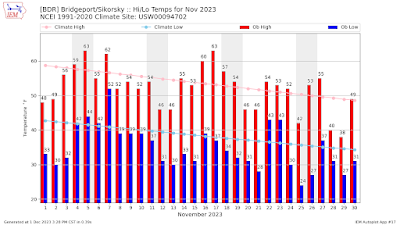
November Featured Cooler- and Slightly Drier-Than-Normal Weather Across Southwestern Connecticut

November is officially in the rear-view mirror, and the month, not surprisingly, was cooler- and drier-than-normal across southwestern Connecticut.

The average monthly temperature for the 30-day period was 43.6 degrees F, which is 2.4 degrees below normal. Twenty of the 30 days last month featured cooler-than-normal average temperatures. In fact, nine of the last 12 days of the month were colder-than-normal.

The high temperature for November at the Bridgeport climate station was 63 degrees, which occurred November 5th and 17th. The coldest temperature was 24 degrees on November 25th. Fourteen days featured a morning low of 32 degrees or colder.

More than three inches of precipitation (3.07") fell at Bridgeport, which was just 0.04" below normal for the month. Seven days featured at least one-hundredth of an inch of rain; there were four days with at least one-tenth of an inch of rain; there was one day with at least one-half inch of rain; and there was one day with at least one inch of rain.


The greatest 24-hour rainfall happened November 21st and 22nd when 2.61" fell. The first half of the month featured only one day (November 7) with more than one-hundredth of an inch of rain (0.20"). 

Paul